Maximize
Maximize
Maximize
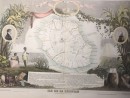
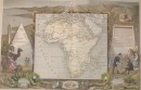
Map of the Islands of Africa Comprising Madagascar, Bourbon and Mauritius (East Africa - Madagascar - Lac Uniamesi) issued in Paris, 1855 by Dufour. Engraved by Erhard. Lithographed by Tanneur and Co. Excellent small old map from the mid-19th century. Original hand color. Unusual focus on the island of Madagascar, with a profusion of interior details not very visible at this date. Note also for the fictitious form given to Lake Uniamesi in western Mozambique and Zanzibar. Clean and well preserved antique map with a fine patina and visual appeal. Original fold line as issued. 31.5 X 24.5 cm, very good condition.11 other products in the same category: